- Homepage
- Author
- Aleister Crowley (10)
- Anonymous (12)
- C H Spurgeon (10)
- Charles Dickens (25)
- Edgar Allan Poe (14)
- God (22)
- John Dee (21)
- L. Frank Baum (10)
- Lewis Carroll (41)
- Louisa May Alcott (10)
- Maria Parloa (9)
- Mark Twain (8)
- Mixed Authors (11)
- Rudyard Kipling (24)
- Selected (8)
- Unknow (8)
- Unknown (32)
- Various (41)
- Walter Scott (9)
- William Shakespeare (28)
- ... (5064)
- Binding
- Cloth (54)
- Cloth & Boards (2)
- Disbound (3)
- Fine Binding (204)
- Framed (2)
- Good (8)
- Hardback (115)
- Hardcover (1128)
- Hardcover / (4)
- Hardcover W / Jacket (3)
- Leather (504)
- Leather / Hardcover (4)
- Manuscript (26)
- Original Copy (99)
- Paperback (6)
- Pigskin (2)
- Softcover (3)
- Softcover, Wraps (87)
- Spiral (2)
- Vellum (54)
- ... (3107)
- Language
- Publisher
- Antiquity (47)
- Cassell (7)
- Collector Books (13)
- David Mckay (6)
- Doubleday (7)
- Estes And Lauriat (9)
- Frank Leslie (6)
- Funk & Wagnalls (9)
- Grosset & Dunlap (22)
- Harper & Brothers (14)
- Lille, Blocquel (7)
- Macmillan (14)
- Macmillan And Co. (13)
- Passmore & Alabaster (6)
- Roberts Brothers (6)
- Selected (6)
- The Century Company (9)
- Transylvania Amira (7)
- Unknown (12)
- Various (24)
- ... (5173)
- Subject
- Americana (63)
- Art & Photography (57)
- Children's (183)
- Classic Literature (12)
- Cooking (44)
- Exploration & Travel (51)
- History (278)
- Illustrated (31)
- Law & Government (20)
- Literature (12)
- Literature & Fiction (297)
- Military & War (17)
- Misc (12)
- Outdoor & Nature (15)
- Philosophy (15)
- Poetry (14)
- Reference (52)
- Religion, Bibles (17)
- Science & Medicine (113)
- Sports & Recreation (12)
- ... (4102)
- Topic
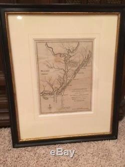
RARE 1781 Revolutionary War Map, Cape Fear River, Wilmington, North Carolina, NC


Cape Fear River, with the Counties Adjacent, and the Towns of Brunswick and Wilmington, against which Lord Cornwallis, Detached Part of his Army, the 17th. This interesting and scarce map depicts the Cape Fear River vicinity near the close of the Revolutionary War. Wilmington was captured by the British in 1781 and plantations in the Cape Fear area were ransacked. The map shows numerous locations including Mount Misery, Wilmington, Brunswick and Lockwoods Folly with notations of their distance from Charlestown, from which General Cornwallis launched his attack on the region. Fort Johnson, which had been destroyed at the outbreak of the war, is also shown.
Size is 7 x 9.5 inches. Beautifully matted with a glass-covered frame. Ref: Jolly #POL-22; Sellers & Van Ee #1512.
The item "RARE 1781 Revolutionary War Map, Cape Fear River, Wilmington, North Carolina, NC" is in sale since Tuesday, April 2, 2019. This item is in the category "Antiques\Maps, Atlases & Globes\North America Maps". The seller is "crottsy" and is located in Clemmons, North Carolina.
This item can be shipped to United States, United Kingdom, China, Mexico, Germany, Japan, Brazil, France, Australia, Denmark, Romania, Slovakia, Bulgaria, Czech republic, Finland, Hungary, Latvia, Lithuania, Malta, Estonia, Greece, Portugal, Cyprus, Slovenia, Sweden, South Korea, Indonesia, South africa, Thailand, Belgium, Hong Kong, Ireland, Netherlands, Poland, Spain, Italy, Austria, Bahamas, Israel, New Zealand, Singapore, Switzerland, Norway, Saudi arabia, Ukraine, United arab emirates, Qatar, Bahrain, Croatia, Malaysia, Panama, Jamaica, Barbados, Bangladesh, Bermuda, Brunei darussalam, Bolivia, Ecuador, Egypt, French guiana, Guernsey, Gibraltar, Guadeloupe, Iceland, Jersey, Jordan, Cambodia, Cayman islands, Liechtenstein, Sri lanka, Luxembourg, Monaco, Macao, Martinique, Maldives, Nicaragua, Oman, Peru, Pakistan, Paraguay, Reunion, Viet nam, Uruguay, Colombia.
- Date Range: 1700-1799
- Year: 1781
- Country/Region: United States of America
- US State: North Carolina
- City: Wilmington
- Format: Sheet Map
- Original/Reproduction: Vintage Original

